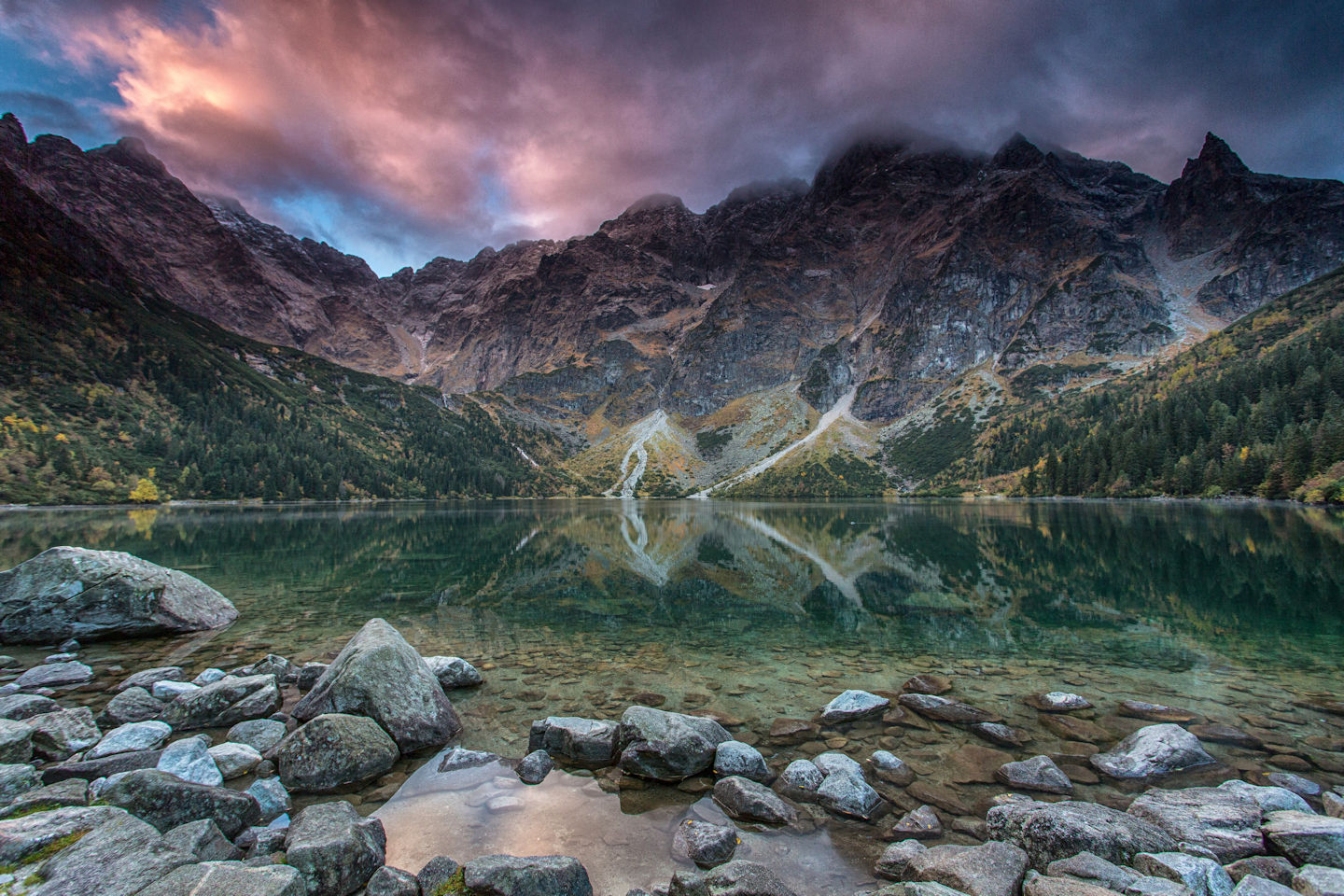
Morskie Oko Lake
This is the largest and the most beautiful lake in the Tatra Mountains. Morskie Oko (literally: “The Eye of the Sea”) is surrounded by the highest summits of the Polish Tatras. It lies in a basin which forms the upper part of the Rybi Potok (“Fish Brook”) Valley. The old name of the lake is Rybi Staw (“Fish Pond”) after trout living in its water.
This is an absolutely amazing place which looks different depending on a season, a time of the day, or weather. Warm and bright vacation days teeming with thousands of tourists and strollers are completely different from snowy and frosty winters, or warm and sunny spring days with frequent great avalanches coming down the slopes surrounding Morskie Oko Lake. There may be a sudden spell of winter in autumn with 76 cm of heavy loose snow, fallen trees around and frost of -15oC. And only a couple of days before there was autumn with its languid warmth and days becoming shorter.
Morskie Oko has been famous for its beauty and uniqueness for a long time. "It is said that being in the Tatras and not visiting Morskie Oko Lake is like being in Rome and not seeing the Pope. It is so renowned that many tourists travel to the Tatra Mountains just to see Morskie Oko." These words were written by Walery Eljasz in 1873 and after so many years they are still true, because you can skip Łomnica Peak, leave out Mylna Cave, omit Mount Kościelec, but Morskie Oko Lake is a must-see. And the majority of tourists coming to the Tatra Mountains are bound to visit it.
With its magnificence and distinctiveness, Morskie Oko has always been a source of countless inspirations. Tourism, climbing, the whole domain of scientific research based on invaluable natural properties of the region, or numerous human activities recorded in a history of experiences and feelings. In the mountain hut, on a summit, on a mountain face.
The surface of the lake lies at an altitude of 1395 m a.s.l. in the Rybi Potok (“Fish Brook”) Valley (the old name of Morskie Oko is "Rybi Staw" – “Fish Pond”). The lake is surrounded on its three sides first with the forest and higher with rocky summits and peaks. In the east there is the Żabie Ridge (Żabia Czuba 2079 m a.s.l., Żabi Niżni Summit 2098 m a.s.l., Żabi Wyżni Summit 2259 m a.s.l.), in the south-east there are: Niżne Rysy (2430 m a.s.l.) and Rysy (2499 m a.s.l.) Here the ridge turns west, through Żabi Koń (2291 m a.s.l.), Żabia Turnia Mięguszowiecka (2336 m a.s.l.), Wołowa Turnia (2373 m a.s.l.), Mięguszowiecki Summits (Czarny (Black Peak) 2404 m a.s.l., Pośredni (Middle Peak) 2393 m a.s.l., Wielki (Grand Peak) 2438 m a.s.l.), Cubryna (2376 m a.s.l.) to Szpiglasowy Wierch (Szpiglasowy Summit 2172 m a.s.l.). Further on, the ridge turns north and through Miedziane (2233 m a.s.l.) and Opalone (2115 m a.s.l.) closes the surroundings of Morskie Oko Lake. The distinctive silhouette of Mount Mnich (2070 m a.s.l.), the outline of a postglacial cirque at Czarny Staw (Black Lake, 1583 m a.s.l.) and the dark face of Kazalnica (2159 m a.s.l.) are the characteristic elements of the landscape around Morskie Oko.
Morskie Oko Lake in numbers
- Distance from Zakopane by the shortest route – 31 km
- Distance in a straight line from Zakopane – 14 km
- Altitude – 1395 m a.s.l.
- Surface of the lake – 34 ha
- Depth – 51.4 m
- Length – 862 m
- Width – 566 m
- Capacity – 9 940 000 m3
- Circumference – ca. 2.6 km
- Surface of the Rybi Potok Valley – 11.5 km2
Walks
- Polana Palenica Białczańska – Morskie Oko Lake – around Morskie Oko Lake – back. On foot or by a horse-drawn fiacre. The whole trip lasts 6-7 h including transport from Zakopane. When there is no show, light sports shoes or sandals are sufficient. There is a path around Morskie Oko Lake and it takes ca. 1 h to go round the Lake (including time to rest and take photos). A nice and pleasant walk on condition that there are not too many people on the trail. Red markers
 , either direction, in some places (Szeroki and Marchwiczny Gullies) there is snow even the end of May.
Easy hikes
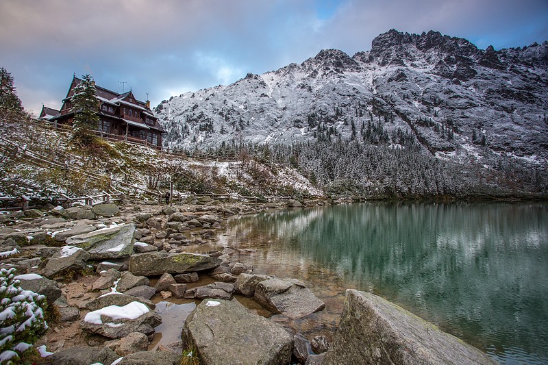
- Morskie Oko – Czarny Staw (Black Lake). Red markers Around 2-3 h there and back. A nice and informative hike. 185 m above Morskie Oko Lake, a quite steep climb, a comfortable stone path. A walk back can be combined with going around Morskie Oko Lake. This is virtually a must-see of a trip to Morskie Oko.
- Wodogrzmoty Mickiewicza (Mickiewicz Waterfalls) – Dolina Roztoki (Roztoka Valley) – Dolina Pięciu Stawów (Five Lakes Valley) – Świstowa Czuba – Morskie Oko. Blue and green markers

 A beautiful and moderately difficult classic hike, recommended for fit tourists. Behind the bridge at Mickiewicz Waterfalls the trail turns right and follows a stone road, quite steep at the beginning. Green markers lead along the valley bottom, on the way there is a charming Nowa Roztoka glade. After 40 min, black markers
  turn left and lead directly to the Mountain Hut in the Five Polish Lakes Valley. Otherwise, it is possible to go further along green markers, passing Siklawa Waterfall on the right, especially beautiful when water is high. After crossing the rock step there is Wielki Staw (Great Lake), blue markers lead to the left and after 10 min the trail reaches the Pięć Stawów (Five Lakes) Mountain Hut in Dolina Pięciu Stawów Polskich (the Five Polish Lakes Valley) at 1670 m a.s.l. A stone path climbs up from the Hut to Świstowa Czuba 1763 m a.s.l. with lovely views over Dolina Roztoki (Roztoka Valley), Buczynowa Dolinka (Buczynowa Valley) and Pięć Stawów (the Five Lakes). Next, the path turns right through Świstówka Roztocka to Kępa (Wolarnia) – a grassy plain on the central part of the Opalone ridge. Spectacular views over Morskie Oko Lake, Czarny Staw (Black Lake) and gigantic summits of the High Tatras. From Kępa 1683 m a.s.l. the trail descends, traversing the meadows of Żleb Żandarmerii (Gully of Gendarmerie). Morskie Oko Lake is reached in 40 min from Kępa, in ca. 2 hours from Pięć Stawów and in 3-5 h from Wodogrzmoty Mickiewicza. Together with getting from Polana Palenica to Wodogrzmoty (ca. 40 min) and descending from Morskie Oko to Polana, this is a popular hike without staying overnight in the mountain hut.
 - Morskie Oko – Wrota Chałubińskiego (Chałubiński Gate) – Szpiglasowy Wierch (Szpiglasowy Summit) – Pięć Stawów (Five Lakes) – Morskie Oko. Yellow markers
 lead from Morskie Oko along the so-called "ceprostrada" through Miedziane slopes (2233 m a.s.l.), then in zigzags, and after 50 min reach a fork of the trails at Dolinka za Mnichem valley. Next, red markers lead along the valley bottom. At a high water level the valley basin is submerged and it is necessary to walk around it. At the end there is a steep climb to Wrota Chałubińskiego (2022 m a.s.l.). A nicely formed mountain pass in the main ridge of the Tatras, interesting views over Dolinka Piarżysta valley. 1.5-2.5 h from Morskie Oko. Back to the fork of the trails (40 min), yellow markers lead to the left in zigzags to Szpiglasowa Przełęcz (Szpiglasowa Pass, 2010 m a.s.l) and along a branch of the path to Szpiglasowy Wierch (Szpiglasowy Summit, 2172 m a.s.l.), 1 h from the fork of the trails. Beautiful and vast views from the summit to all directions. Descent to Dolina Pięciu Stawów (the Five Lakes Valley), first in quite precarious terrain (chains), next along a comfortable path through meadows and stretches of dwarf mountain pine, then along blue markers . Pięć Stawów (Five Lakes) Mountain Hut is 1-1.5 h from Szpiglasowy Wierch. Then a path with blue markers leads to Morskie Oko (as described above). The whole trip takes 6-10 hours, depending whether or not Wrota Chałubińskiego is climbed. This is a technically easy hike, with splendid views, preferably with staying overnight in the Hut.
More difficult hikes
-
Morskie Oko – Mount Rysy. For obvious reasons, this is the most frequently visited summit in the Morskie Oko region. Red markers
lead from Czarny Staw (Black Lake) on the left of the lake, next up a path, zigzagging at times. Bula pod Rysami (2050 m a.s.l.), ca. 1.5 h from Czarny Staw. Even in July there may be patches of snow on the way. Then the ground gets quite loose and the chains begin. A rule to remember: one stretch of a chain = one person!!! When the trail is crowded, this rule demands patience and politeness. Mount Rysy (2499 m a.s.l.), a lower and broader peak, a spectacular and vast panorama. It may be crowded in high season. 2.5-4 h from Morskie Oko. The trail is moderately difficult technically, but physical fitness and a head for heights are a must. The trip should preferably include accommodation in the Hut, in the following order: staying overnight in the Hut, early wake-up, going out to the mountains. - Morskie Oko – Przełęcz pod Chłopkiem (Pod Chłopkiem Pass). Many tourists consider it the most beautiful path in the Tatra Mountains. From Czarny Staw (Black Lake) green markers go up and to the right, first through fields of dwarf mountain pine and via Bula pod Bandziochem, than on scree. Further on, larger exposure at times, step irons. Kazalnica (2159 m a.s.l.) – an inconspicuous peak with its famous face descending towards Czarny Staw. 2-3 h from Morskie Oko. Then the trail goes for 40 min in quite precarious terrain to Przełęcz pod Chłopkiem (Pod Chłopkiem Pass, 2307 m a.s.l.). Interesting views, a remarkable hike, not so many people on the trail even in high season. 2-4 hours from Morskie Oko. The trip should preferably include accommodation in the Hut with leaving for the mountains early in the morning.
How to prepare
- Preparation for a hike means not only exploration of topography but also selection of your mountain gear. Packing a small rucksack for a one-day stroll is different than packing a large backpack for a week’s stay in the Old Hut with winter climbing. However, there is one general rule: only necessary things!!!
- A subjective list of necessary extras to your equipment:
- a litterbag
- for smokers: an empty soft drink bottle or pesto jar
- gloves, important also in summer (chains)
- a camera
- a torch
- a map

